


Institution/Author: The Academy of Applied Technical and Preschool Studies – Department Vranje, Serbia/dr Jovana Džoljić
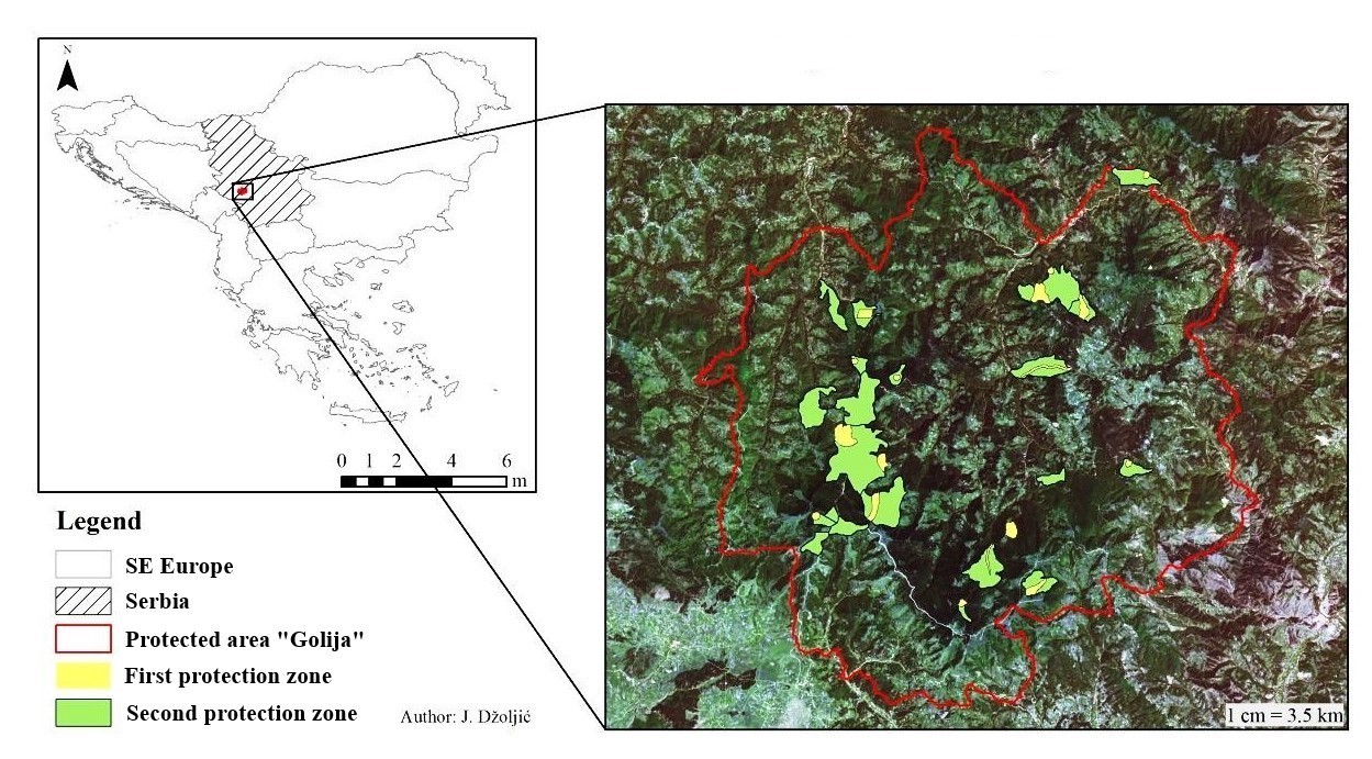
By the Decree of the Government of the Republic of Serbia from 2001 (“Official Gazette of RS No. 45/01”), the Golija Mountain area was declared a nature park in order to preserve the cultural and natural values of this area. Also, the natural created values in this area have met the criteria of the UNESCO program “Man and Biosphere”, and part of the territory was declared in the same year the Golija-Studenica Biosphere reserve.
Today remote monitoring is the best available technology for detecting changes in nature (Eastman et al, 2013; Osunmadewa, Csaplovics, Majdaldin, Adeofun, & Aralova, 2017; Džoljić, 2017). The analysis of LANDSAT satellite images from the period prior to the designation of the Golija area for the protected area and 15 years after, allows the monitoring of changes in the vegetation cover. Satellite images are taken from the open USGS database. Classification methodology, the supervised classification method is used for analysis, enables the extraction ov different classes or topics from unprocessed satellite images, and includes preliminary pre-processing of images (Džoljić, 2017)
The main economic activities in the area of Golija Mountain are forestry, livestock, agricultural activity, grazing as well as the collection of wild and cultivated species of aromatic and medicinal plant species, mushrooms, forest fruits, etc. However, the lack of investment and economic crisis has led to a decrease in the living standard of the population , which is confirmed by the negative population trend in this area as well as the migration of the local population to cities (Džoljić, 2017). All this led to reduced anthropogenic pressure on this area, which together with applied conservation measures caused the recovery of vegetation. The results of the analysis (Image 1 and 2) showed an increase in the area under the forest in the analyzed period by 6 %, most likely due to the applied measures of protection and recovery of vegetation, which is confirmed by the reduction of the area under the transition class forest-shrub surface by 3 % Tab below). Reduced anthropogenic pressure also greatly contributes to the recovery of vegetation. Reduction of the surface was also observed in the class of the area with diluted vegetation by 2 %, while the area of natural grasslands increased by 5 %, which can be explained by reduced anthropogenic pressure and natural succession of vegetation. The negative demographic trend and the abandonment of the village can also explain the reduction of areas under agricultural land by 4.42 %. The class of bare surfaces occupies the smallest area, but there is a decrease in the area of this class due to the recolonization of such spaces. Also, it should be kept in mind that due to small areas and insufficiently representative samples, a technical error may occur, that is, the vastness of these classes is replaced by artificial areas, which may indicate an incorrect result.
The change in the class of the artificial surface is less than 1 %. This class includes mainly roads as well as objects that have not changed in the analyzed period. Only areas that were under fire in 2010 and 2012 are changed but they are a subject to natural regeneration, and a change of 0.3 % can be attributed to the recovery of these habitats.
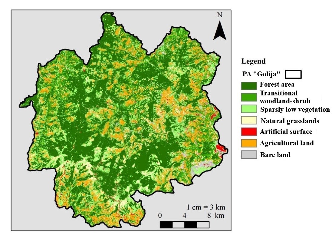
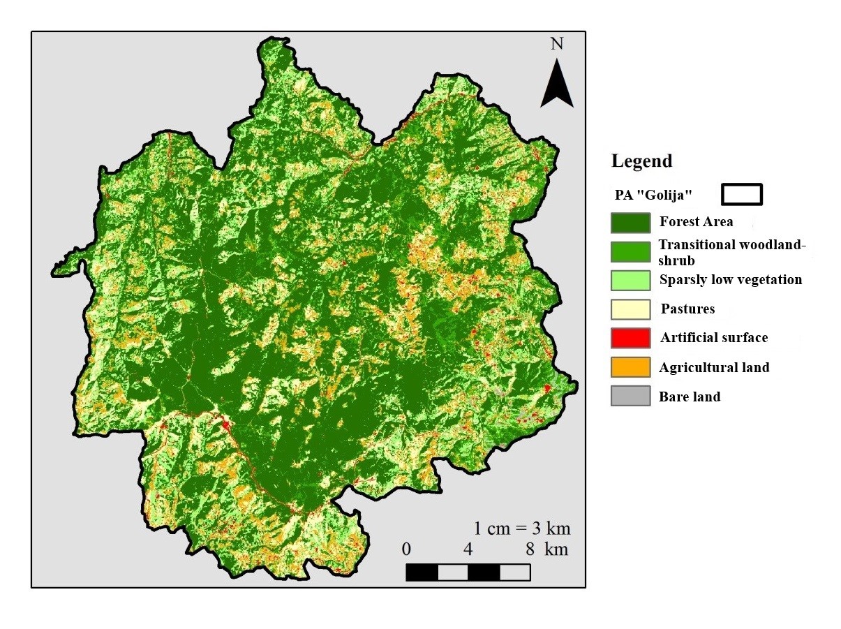
Table: Representation of vegetation classes in 2000 and 2014
Area (ha) 2000 | % | Area (ha) 2014 | % | |
Forest | 30 966 | 41 | 35 821 | 47 |
Transitional woodland/shrub area | 12 967 | 17 | 10 466 | 14 |
Area with diluted vegetation | 13 970 | 18 | 11 992 | 16 |
Pastures | 5 152 | 7 | 8 977 | 12 |
Artificial surfaces | 1 069 | 1 | 1 296 | ~2 |
Agriculture surfaces | 10 379 | 14 | 7 028 | 9 |
Bare surfaces | 1 360 | 2 | 284 | <1 |
Enlargement the area of artificial surfaces indicates a possible increase in anthropogenic pressure in the future. The increasing rural, ethno or eco-tourism should not be ignored because it contributes to the reconstruction of rural households. Together with investing in infrastructure and improving connectivity with larger cities, it will undoubtedly lead to the popularization and development of this site, which will influence the surface change of the agricultural and urbanized areas. Therefore, changes in soil cover and habitat types must be closely monitored.
Literature:
Džoljić, J. (2017). Change detection in vegetation cover and size of urbanized zones at UNESCO Biosphere reserve “Golija-Studenica”, Serbia (Master Thesis). Departement of Geoinformation in Environmental Management, CIHEAM-Mediterranean Agronomic Institute of Chania (MAICh), Chania, Greece.
Eastman, J. R., Sangermano, F., Machado, E. A., Rogan, J., & Anyamba, A. (2013). Global trends in seasonality of normalized difference vegetation index (NDVI), 1982–2011. Remote
Sensing, 5(10), 4799-4818.
Osunmadewa, B. A., Csaplovics, E., Majdaldin R. A., Adeofun, C. O., & Aralova, D. “Regional assessment of trends in vegetation change dynamics using principal component analysis”, Proc. SPIE 9998, Remote Sensing for Agriculture, Ecosystems, and Hydrology XVIII, 99981Y (25 October 2016); doi: 10.1117/12.2242011; https://doi.org/10.1117/12.2242011
Popovic, S., & Dzoljic, J. (2016). Serbian Forest Indicators by CORINE Land Cover. Saarbucken, Germany: LAP LAMBERT Academic Publishing. Retrieved from http://www.sepa.gov.rs/download/publikacije/SerbianForestIndicatorsCorineLandCover.pdf