Institution/Author: Provincial Institute for Nature Conservation/Dr Biljana Panjković
The first step towards the formation of the ecological network of Serbia was the designation of the Emerald Network area with the implementation of the Convention on the Conservation of European Wildlife and Fauna and Natural Habitats. The establishment of an ecological network of areas of importance for the EU started in 2009 within the Twining SR07-IB-EN-02 project “Strengthening the Administrative Capacity of Protected Areas in Serbia – Natura 2000”. The Law on Nature Protection (2009) defines the notions related to the ecological network, and the tasks related to the establishment, as well as measures for the protection and improvement of the network are defined by the Regulation on the ecological network of the Republic of Serbia (2010). Based on the Regulation of the ecological network, the Provincial Institute identifies the boundaries of parts of the ecological network in the area of AP Vojvodina. In addition to the protected areas, it also keeps a database of habitats of strictly protected and protected species, as well as habitat types important for the conservation of biological diversity, in accordance with the relevant Regulations. By the end of 2018, 665 spatial units were identified, with total area of 163,900 ha, or about 7.61% of the area of AP Vojvodina. Habitats were identified on the basis of field data, and presented in the form of limited areas, within which the coverage of the main habitat categories was estimated at an accuracy of 5 % to 10 %. In the area of the Province, ecological corridors of regional importance and a large number of local corridors have been identified. The database is complemented in conjunction with identification and habitat mapping activities, and is publicly available in accordance with the law. National ecological network (in Vojvodina): 665 spatial units, total area of 163,900 ha (7.61%)Total under the ecological network 16.52% (protected areas and habitats of strictly protected species of spatial units).
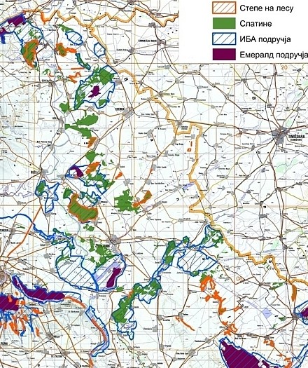
Map 1: Ecological network in Vojvodina
2012 Provincial Institute for Nature Conservation “Expert documentary basis in the area of nature protection for the preparation of the Spatial Plan for the specific purposes of the multifunctional ecological corridor Tisa” – the Regulation on the ecological network of the Tisa River is defined as an ecological corridor of international importance. The study included identification of natural values within the scope of the plan, as well as the assessment of the functionality and accessibility of the Tisa river corridor and the salt marsh-steppe corridor Banat. The data and measures provided guidelines for determining the uses of spatial units within the river corridor, as well as in the zone of influence on the Tisa corridor.